File:Map of Ethnic Groups in Afghanistan, by district.svg

Size of this PNG preview of this SVG file: 750 × 475 pixels. Other resolutions: 320 × 203 pixels | 640 × 405 pixels | 1,024 × 649 pixels | 1,280 × 811 pixels | 2,560 × 1,621 pixels.
Original file (SVG file, nominally 750 × 475 pixels, file size: 1.69 MB)

| Description |
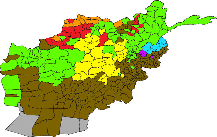
English: Map showing the largest ethnic group in each district of Afghanistan. It should be noted that the population of Afghanistan is not determined by districts. Also, this map has major errors because it is missing Aimaks, Kyrgys, Qizilbash, and Brahuis who are different ethnic groups mentioned by names in the Constitution of Afghanistan (chapter 1, article 4), the Afghan National Anthem, in all the encyclopedias including Encyclopedia Britannica and Encyclopedia Iranica as well as in the CIA Factbook and on all the official ethnolinguistic maps of Afghanistan that you see in the media. See the official CIA maps below, which are professionally made by government employees and includes all the ethnic groups of Afghanistan. If somebody wants to create their own maps they should be based on these official CIA maps.
Tajik
Pashtun
Hazara
Uzbek
Turkmen
Baloch
Nuristani
Pashai
Below are official CIA maps showing all ethnic groups of Afghanistan
|
| Date | |
| Source |
|
| Author | Lokal_Profil & Le Behnam |
| Permission (Reusing this file) |
This file is licensed under the Creative Commons Attribution-Share Alike 2.5 Generic license. Attribution: Lokal_Profil
|


_in_Afghanistan.jpg)
File history
Click on a date/time to view the file as it appeared at that time.
| Lusuku/Sikhatsi | Thumbnail | Dimensions | Umuntfu | Comment | |
|---|---|---|---|---|---|
| current | 22:10, 3 iNdlovu 2009 | | 750 × 475 (1.69 MB) | Lokal Profil | COrrection |
| 18:23, 1 iNdlovu 2009 |  | 750 × 475 (1.69 MB) | Lokal Profil | {{Information |Description={{en|Map showing the largest ethnic group in each district in Afghanistan. }} {{legend|#7c6300|Pashtun}} {{legend|#62ff00|Tajik}} {{legend|#fffc01|Hazhara}} {{legend|#ed1b24|Uzbek}} {{legend|#fe9901|Turkmen}} {{legend|#19deff|Nu |
File usage
The following page uses this file:
Global file usage
The following other wikis use this file:
- Usage on hi.wikipedia.org
- Usage on hu.wikipedia.org
- Usage on mk.wikipedia.org
- Usage on sr.wikipedia.org
- Usage on tg.wikipedia.org
- Usage on tr.wikipedia.org