File:Topographic map of Cape Verde-en.svg

Size of this PNG preview of this SVG file: 800 × 594 pixels. Other resolutions: 320 × 238 pixels | 640 × 475 pixels | 1,024 × 760 pixels | 1,280 × 950 pixels | 2,560 × 1,901 pixels | 1,464 × 1,087 pixels.
Original file (SVG file, nominally 1,464 × 1,087 pixels, file size: 245 KB)
Summary
| Description |
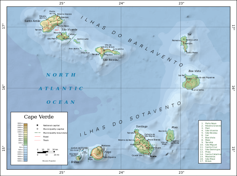
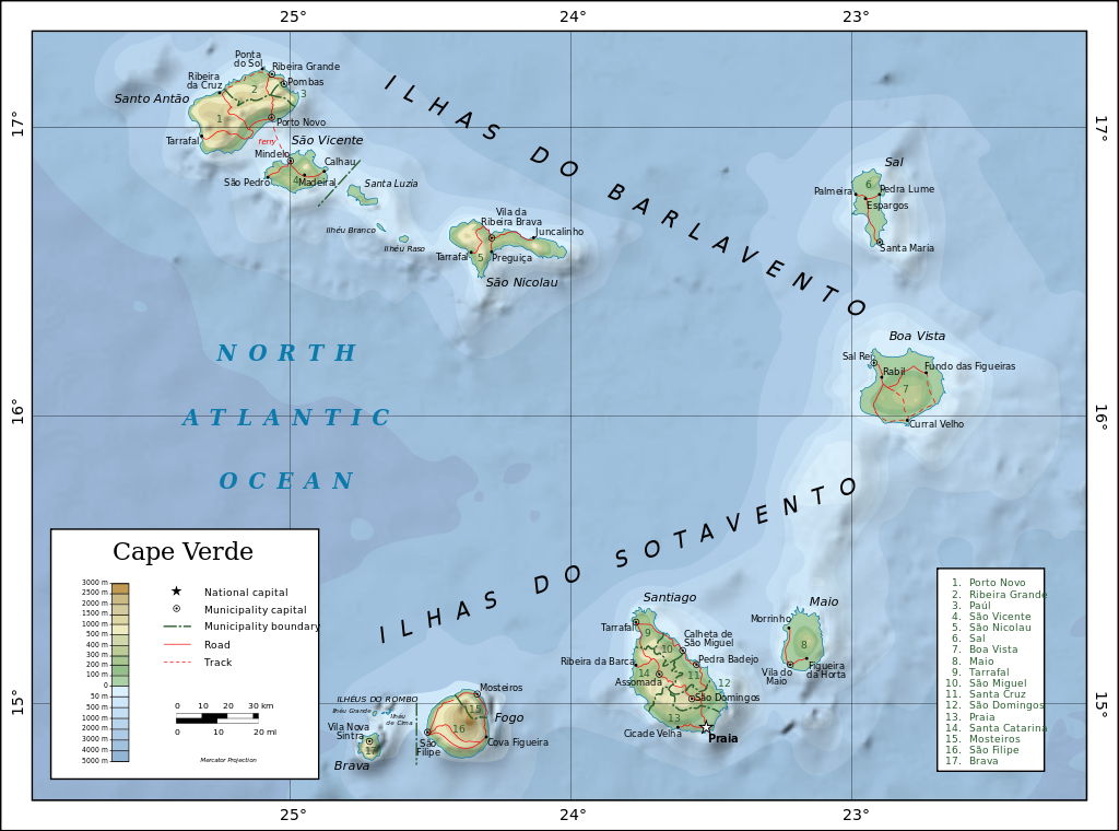
English: Topographic map of Cape Verde.
Dansk: Topografisk kort over Kap Verde.
Español: Mapa topográfico de Cabo Verde.
Suomi: Kap Verden topografinen kartta.
Français : Carte topographique du Cap-Vert.
Македонски: Карта на Зелен ’Рт.
Русский: Топографическая карта Кабо-Верде. Македонски |
| Date | |
| Source |
Self-made in Inkscape.
|
| Author | Oona Räisänen (Mysid) |
| Other versions |
|
| SVG genesis |


Licensing
I, the copyright holder of this work, hereby publish it under the following licenses:

|
Permission is granted to copy, distribute and/or modify this document under the terms of the GNU Free Documentation License, Version 1.2 or any later version published by the Free Software Foundation; with no Invariant Sections, no Front-Cover Texts, and no Back-Cover Texts. A copy of the license is included in the section entitled GNU Free Documentation License. |
This file is licensed under the Creative Commons Attribution-Share Alike 4.0 International, 3.0 Unported, 2.5 Generic, 2.0 Generic and 1.0 Generic license.
- You are free:
- to share – to copy, distribute and transmit the work
- to remix – to adapt the work
- Under the following conditions:
- attribution – You must give appropriate credit, provide a link to the license, and indicate if changes were made. You may do so in any reasonable manner, but not in any way that suggests the licensor endorses you or your use.
- share alike – If you remix, transform, or build upon the material, you must distribute your contributions under the same or compatible license as the original.
You may select the license of your choice.
File history
Click on a date/time to view the file as it appeared at that time.
| Lusuku/Sikhatsi | Thumbnail | Dimensions | Umuntfu | Comment | |
|---|---|---|---|---|---|
| current | 12:12, 21 iNyoni 2010 | | 1,464 × 1,087 (245 KB) | Mysid | experiment with shaded relief + letter spacing |
| 09:36, 19 Kholwane 2010 |  | 1,464 × 1,087 (226 KB) | Mysid | remove raster | |
| 09:35, 19 Kholwane 2010 |  | 1,464 × 1,087 (227 KB) | Mysid | re-upload as valid SVG | |
| 09:31, 19 Kholwane 2010 |  | 1,464 × 1,087 (227 KB) | Mysid | better fonts & other minor layout issues | |
| 12:31, 25 iNkhwekhweti 2008 |  | 1,464 × 1,087 (277 KB) | Mysid | oops | |
| 12:29, 25 iNkhwekhweti 2008 |  | 1,464 × 1,087 (277 KB) | Mysid | border | |
| 08:02, 19 iNkhwekhweti 2008 |  | 1,382 × 1,008 (276 KB) | Mysid | bugfix #1 | |
| 08:01, 19 iNkhwekhweti 2008 |  | 1,326 × 997 (275 KB) | Mysid | == {{int:filedesc}} == {{Information |Description= {{en|Topographic map of en:Cape Verde.}} {{fr|Carte topographique du fr:Cap-Vert.}} {{fi|fi:Kap Verden topografinen kartta.}} |Source=Self-made in Inkscape.<br/>Boundaries, roads, and pl |
File usage
The following page uses this file:
Global file usage
The following other wikis use this file:
- Usage on arz.wikipedia.org
- Usage on az.wikipedia.org
- Usage on ba.wikipedia.org
- Usage on bn.wikipedia.org
- Usage on ca.wikipedia.org
- Usage on cs.wikipedia.org
- Usage on da.wikipedia.org
- Usage on el.wikipedia.org
- Usage on en.wikipedia.org
- Usage on eo.wikipedia.org
- Usage on es.wikipedia.org
- Usage on eu.wikipedia.org
- Usage on fa.wikipedia.org
- Usage on ff.wikipedia.org
- Usage on fi.wikipedia.org
- Usage on fr.wikipedia.org
- Usage on gag.wikipedia.org
- Usage on gl.wikipedia.org
- Usage on gv.wikipedia.org
- Usage on ha.wikipedia.org
- Usage on hi.wikipedia.org
- Usage on ig.wikipedia.org
- Usage on io.wikipedia.org
- Usage on lfn.wikipedia.org
- Usage on mdf.wikipedia.org
- Usage on mg.wikipedia.org
- Usage on mzn.wikipedia.org
- Usage on nl.wikipedia.org
- Usage on or.wikipedia.org
- Usage on os.wikipedia.org
- Usage on pa.wikipedia.org
- Usage on pl.wikipedia.org
- Usage on pt.wikipedia.org
- Usage on ru.wikipedia.org
- Usage on sah.wikipedia.org
View more global usage of this file.