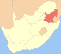
Lifayela:Map of South Africa with Mpumalanga highlighted.svg

Size of this PNG preview of this SVG file: 688 × 600 pixels. Other resolutions: 275 × 240 pixels | 551 × 480 pixels | 881 × 768 pixels | 1,175 × 1,024 pixels | 2,349 × 2,048 pixels | 757 × 660 pixels.
Original file (SVG file, nominally 757 × 660 pixels, file size: 337 KB)
File history
Click on a date/time to view the file as it appeared at that time.
| Lusuku/Sikhatsi | Thumbnail | Dimensions | Umuntfu | Comment | |
|---|---|---|---|---|---|
| current | 22:45, 29 Lweti 2010 |  | 757 × 660 (337 KB) | Htonl | style |
| 18:58, 6 iMphala 2010 |  | 1,071 × 934 (399 KB) | Htonl | styling | |
| 13:39, 5 iMphala 2010 |  | 1,071 × 934 (278 KB) | Htonl | tweak | |
| 07:04, 5 iMphala 2010 |  | 1,071 × 934 (434 KB) | Htonl | use Lambert conformal conic projection | |
| 15:09, 4 Mabasa 2010 |  | 1,000 × 786 (406 KB) | Htonl | cleaner lines | |
| 19:57, 28 Bhimbidvwane 2010 |  | 1,000 × 786 (144 KB) | Htonl | update for GP/NW border change | |
| 23:19, 4 Lweti 2008 |  | 1,000 × 786 (195 KB) | Htonl | {{Information |Description={{en|1=Map of South Africa with Mpumalanga province highlighted. Based on Image:South Africa blank locator map.svg.}} |Source=Own work by uploader |Author=Htonl |Date=2008-11-5 |Permission= |other_versions= } |
File usage
The following page uses this file:
Global file usage
The following other wikis use this file:
- Usage on cs.wikipedia.org
- Usage on en.wikipedia.org
- Usage on fr.wikipedia.org
- Usage on hr.wikipedia.org
- Usage on ka.wikipedia.org
- Usage on ko.wikipedia.org
- Usage on mr.wikipedia.org
- Usage on pl.wikipedia.org
- Usage on pl.wikivoyage.org
- Usage on pnb.wikipedia.org
- Usage on ro.wikipedia.org
- Usage on sv.wikipedia.org
- Usage on tr.wikipedia.org
- Usage on uk.wikipedia.org
- Usage on ve.wikipedia.org
- Usage on vi.wikipedia.org
- Usage on yo.wikipedia.org
